
Contamination of soil and sediment
Contamination of sediments in lakes, rivers and harbours by heavy metals and organic compounds (including polyaromatic hydrocarbons (PAHs) and PCBs) is an important environmental and economical concern in many countries. Health risks associated with these pollutants may restrict activities like fishing and recreation. Moreover, to maintain access for shipping, most waterways and harbours are routinely dredged. An essential waypoint in the management and disposal of such contaminated dredged sediments is their classification on the basis of the degree of pollution. Traditionally, inventories of contamination are made using survey programmes with a relatively limited amount of samples and consequently decisions often have to be made on the basis of incomplete information. Because classification of areas as contaminated or non-contaminated will often have large financial impact, it is essential that information is both reliable and spatially detailed. Especially the latter aspect is generally not realized in sampling surveys, as economical constraints limit the number of samples that are analysed.
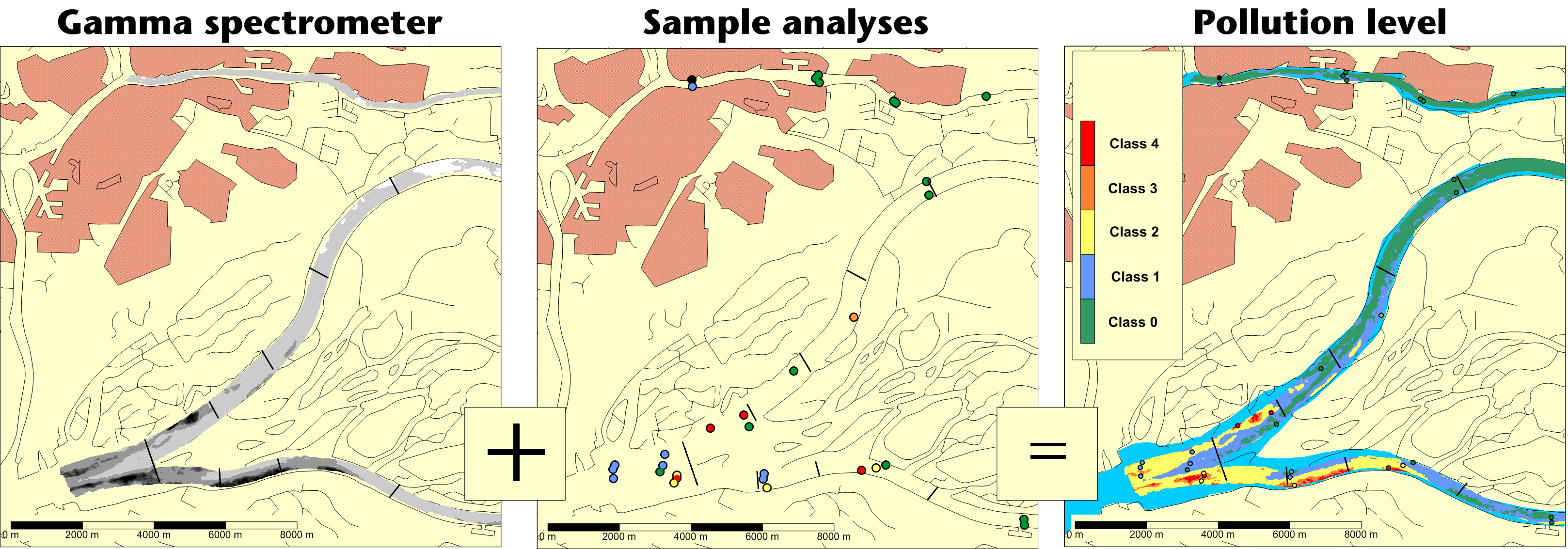
This situation can be improved when the environmental parameter to be assessed correlates with a physical parameter that can be measured in situ with a survey device. By establishing the correlation between both parameters on a limited number of samples, the in situ survey map of a diagnostic physical parameter can be converted into a quantitative map of the distribution of the environmental parameter.
Concentrations of radionuclides can be measured in situ and can therefore be used as a proxy for contaminants. Applications of this method (Koomans and Limburg, 2005; De Meijer et al., 2002) uses the correlation between concentrations of heavy metals and organic micro-contaminants with natural occurring and anthropogenic radionuclides to make synoptic maps of the degree of contamination of extended areas. The method is based on measurements with a gamma-ray scintillation detector that is towed over the sediment bed behind a vessel or on a sensor that is carried on a vehicle over land. This detection system measures gamma-rays being emitted from very low concentrations of a number of radionuclides (e.g., 137Cs, 40K and radionuclides from the decay series of 238U and 232Th) in sediment. Typically, the system needs 1–10 s to accumulate sufficient data such that the gamma-ray spectrum can be decomposed into the contribution of the individual radionuclides. Consequently, the sediment bed of soil can be probed at a few hundred to a few thousand locations per hour. Due to the attenuation of gamma radiation in the sediment, the concentrations measured are characteristic for the top 30–50cm of the sediment or soil.
This text is partly taken from:
Data fusion for inland dredging