
Heavy metal contamination
Gamma-ray measurements can be used to map heavy metal contamination in both terrestrial soils and aquatic sediments, provided a meaningful correlation exists between the contaminants and naturally occurring radionuclides. Understanding the geochemical pathway by which the contamination entered the environment is therefore essential before applying this method.
The role of sediment composition
In aquatic and alluvial systems, many contaminants bind preferentially to fine clay particles (Perk, 2006). Because natural radionuclides such as ⁴⁰K, ²³⁸U and ²³²Th are also enriched in fine-grained material, they serve as reliable proxies for contaminant concentrations, provided the system is locally calibrated. This conceptual relationship is the basis for in situ mapping of contaminated sediment using towed underwater gamma-ray detectors, which allow large areas to be surveyed quickly and economically.
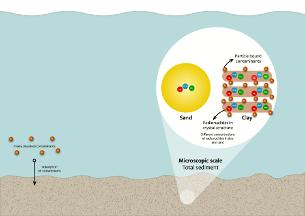
Conceptual relationship between sediment composition and contaminant accumulation in floodplain environments. Fine particles such as clay act as binding sites for heavy metals and organic pollutants and are simultaneously enriched in natural radionuclides, forming the basis for radiometric proxy mapping of contamination (Limburg, Koomans, Veeke, 2026).
Terrestrial applications: a case study from De Kempen
The same principle can be applied to contaminated land, but the correlation between radionuclides and heavy metals must be established independently for each situation. A well-documented example is the zinc slag contamination in the De Kempen region of the Netherlands and Belgium, where zinc slag was used as road fill material until the 1970s across an area of approximately 2,600 km². The slag is rich in heavy metals including zinc, lead and cadmium.
In this case the correlation between radioactivity and contamination does not arise from grain-size binding, but from the geochemical signature of the ore itself. Analysis of 300 soil samples demonstrated that samples containing zinc slag are enriched in uranium, and that the ratio between uranium and thorium deviates from the background value of 1 found in uncontaminated soils. This geochemical fingerprint made it possible to use a gamma spectrometer, mounted on a measurement vehicle, to map zinc slag presence across more than 1,200 km of roads in a non-invasive way.
References
Limburg, J., Koomans, R.L., 2026. Scintillators in the wild: the present and future of gamma-ray sensing in geophysical applications. Radiat Meas 107684. https://doi.org/10.1016/j.radmeas.2026.107684
Uddin, M.K., 2017. A review on the adsorption of heavy metals by clay minerals, with special focus on the past decade. Chem. Eng. J. 308, 438–462. DOI: 10.1016/J.CEJ.2016.09.029