
Sediment mapping
Title | Topic | Year | Download paper |
|---|---|---|---|
An Underwater Gamma Spectrometer as Tool for Ecological Assessment | We describe an approach in which an underwater gamma spectrometer can be used to quantitatively map the concentration of fines in sediments. With this approach, the natural variation of fines and thereby the buffering capacity of the seafloor can be monitored and the natural dynamics due to re-suspension and large-scale sediment transport patterns can be quantified. The information derived from the geophysical measurements give the opportunity to measure the effects of human induced projects at sea. 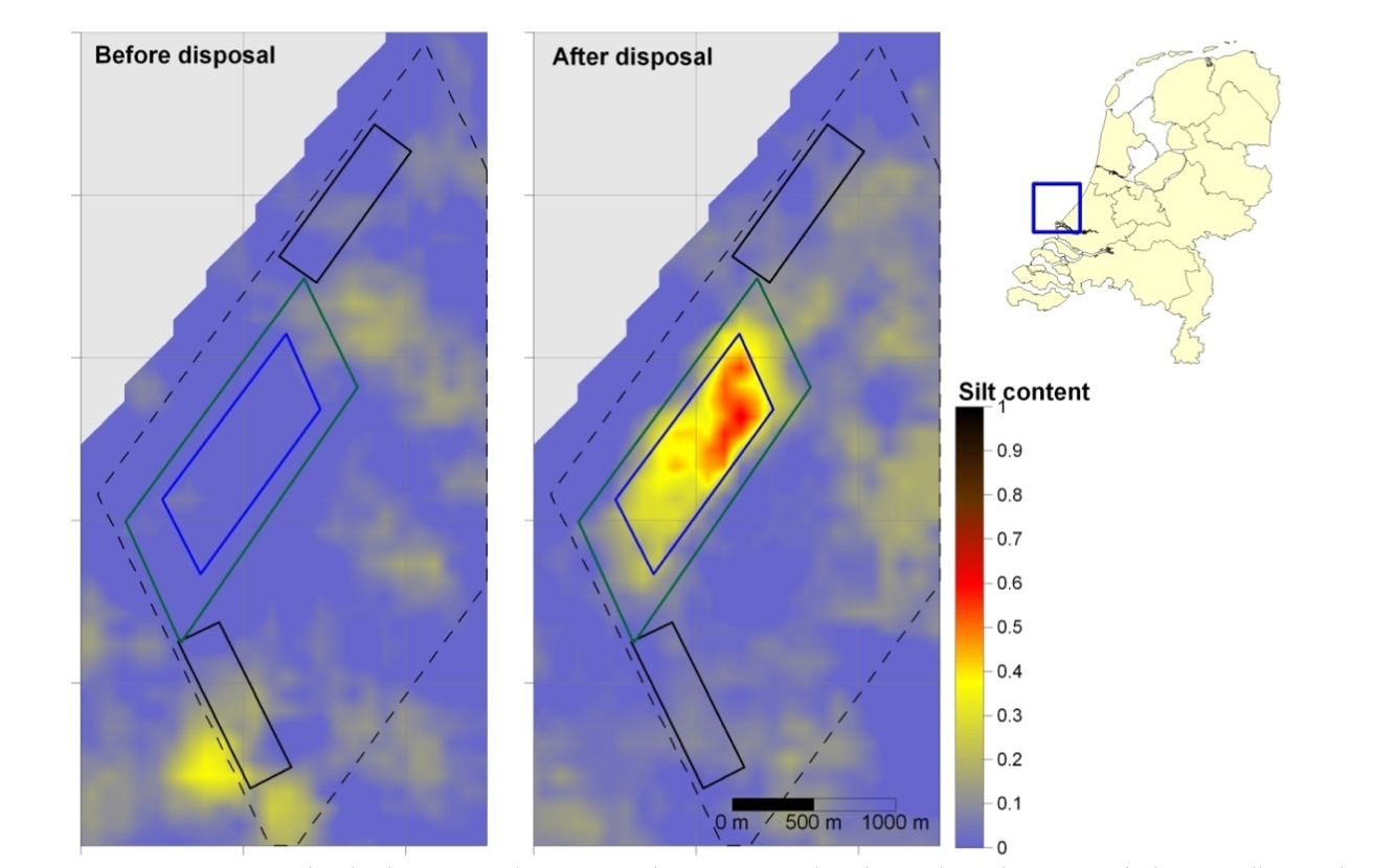 | 2016 | 2016 An Underwater Gamma Spectrometer as Tool for Ecological Assessment.pdf |
Nourishment of the slope of a tidal channel. From theory to practice. | In this project, glauconitic sand was used as a tracer material. Surveys were conducted during one year, using multi beam soundings and the Medusa mapping system. Sediment transport could be clearly observed and after one year a large percentage of nourished material was still present.  | 2005 | |
Sand in motion, Effects of density and grain size | How do properties (like shape, grain size and density) influence sediment transport on the coast? The rearrangements of the sediments are a “silent witness” of sediment-transport processes that acted in that region. If we consider recent deposits, the sediment distribution reflects processes that acted recently, but older formations of sediment can give information on hydrodynamics and sediment-transport processes of the past. However, before the sediment distribution can be coupled to hydrodynamic processes, the inverse question: How can graded sediment distributions give quantitative information on sediment-transport processes? should be solved. These questions are the basis of this thesis. 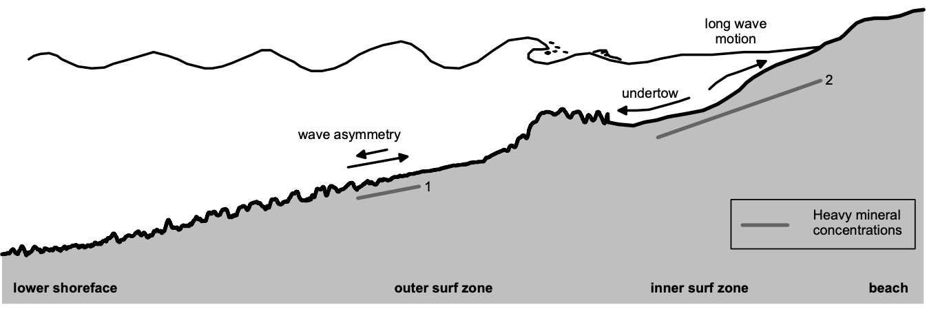 | 2000 | |
Natural radionuclides as tracers of the dispersal of dredge spoil dumped at sea | This paper shows the application of mapping with a gamma-ray spectrometer for monitoring the dispersal of dredgespoi lfrom Rotterdam harbour, dumped in the North Sea. In addition to a qualitative picture of dredge spoil dispersal, a mass–balance equation has been used to quantitatively assess the dredge spoil transport with time.  | 2000 | |
Monitoring sludge disposal | 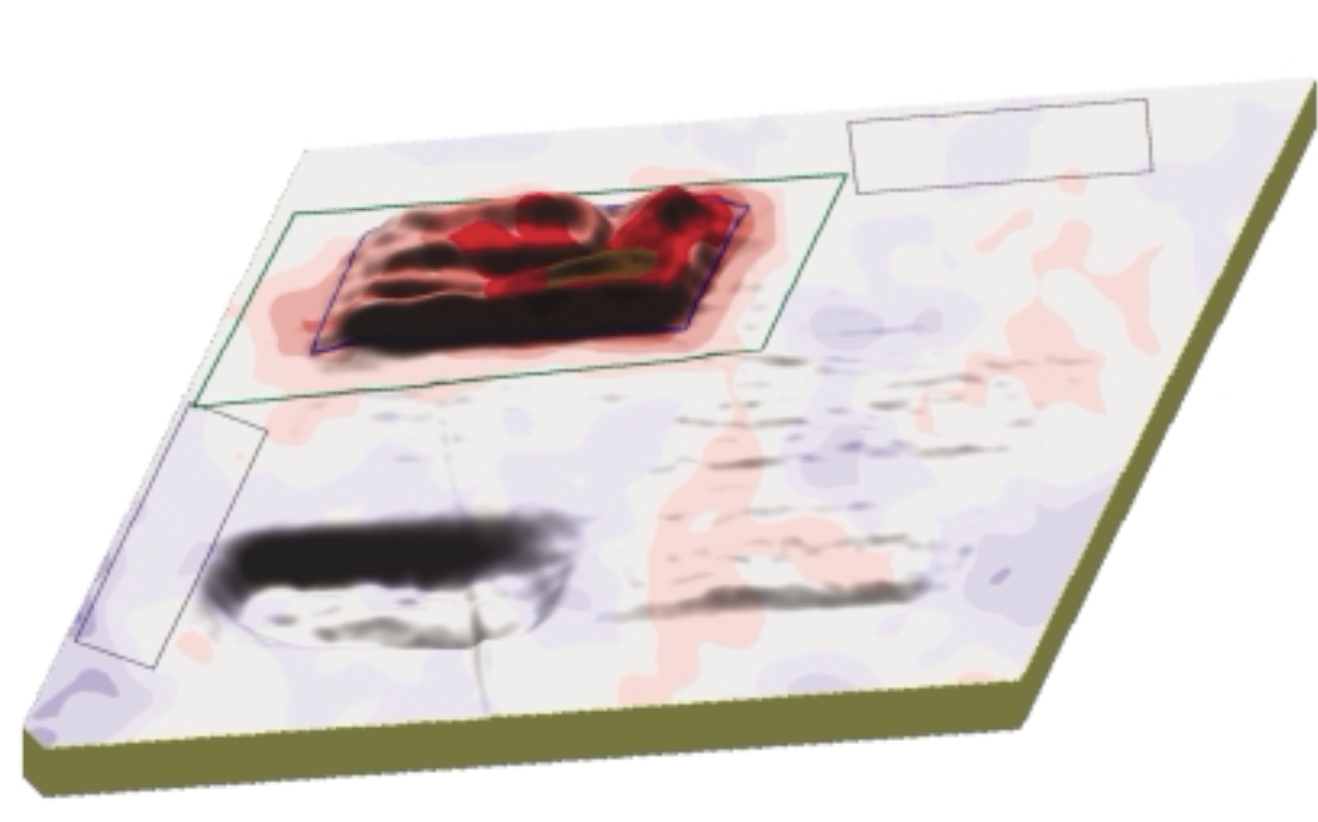 | 2004 | Koomans, Stutterheim - 2004 - Monitoring Sludge Disposal.pdf |
Measuring effects of dredging in relation to the dynamics of nature. | The discharge of fines during dredging and the impact of these fines on seafloor habitats is an important aspect in environmental impact assessments. Our vision is that the effects of dredging on the environment, should be related to the impact of the dynamics of nature itself. 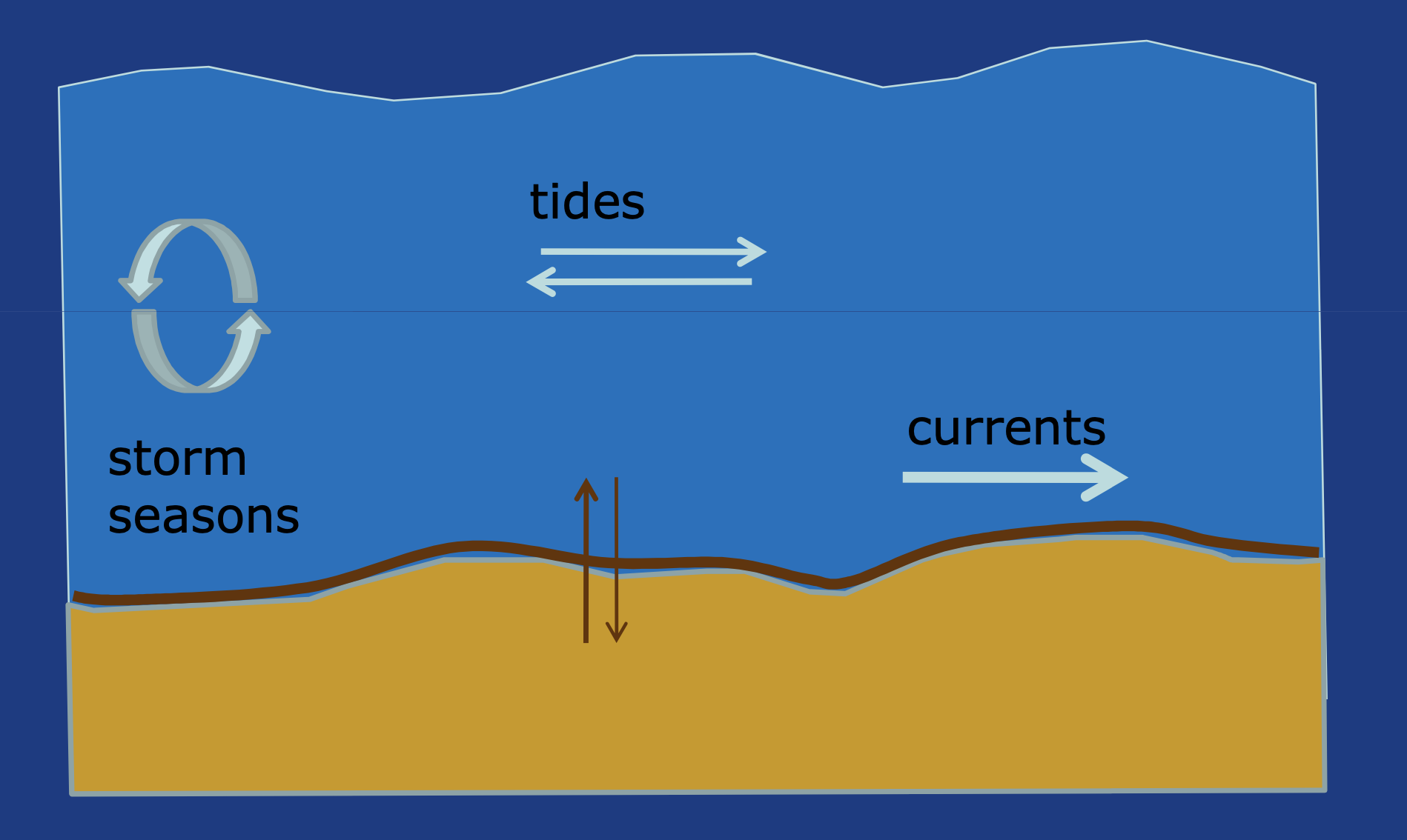 | 2009 | Koomans, Limburg - 2009 - Measuring effects of dredging in relation to the dynamics of nature.pdf |
Density gradation in cross-shore sediment transport | One of the fundamental properties of a coastline is its sediment composition. Coastal sediments are rarely composed of one type of sediment. Due to these differences, the sediments are sorted on the beach and foreshore. The effect of density variations of the sediment on coastal sediment transport has been studied in a wave flume experiment.  | 2004 | Koomans, de Meijer - 2004 - Density gradation in cross-shore sediment transport(2).pdf |
Monitoring silt content in sediments off the Dutch Coast | Silts, present in sand extraction sites, can potentially mobilize in the water column and result in increased turbidity of the North Sea. The main knowledge gap in assessing this potential risk is the capacity to buffer silts in the sandy sediments. We monitored the concentration of fines perpendicular to the coast in 6 campaigns. Measurements show that, although the silt content is very low (<5%), the silt content can vary strongly on small spatial and temporal scales. Comparing silt concentrations to the daily averaged wave height before the measurements, indicates that the silt contents in the sediment bed increase with declining wave height. 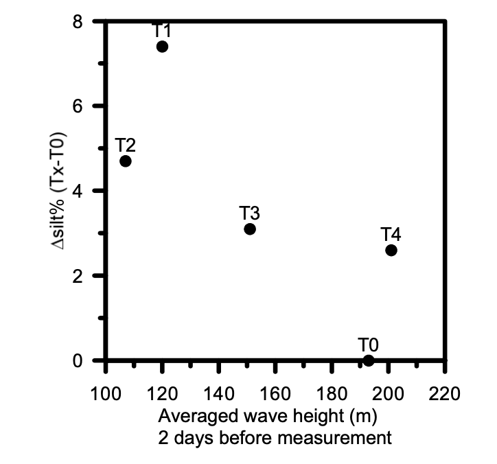 | 2012 | Koomans et al. - 2012 - Monitoring silt content in sediments off the Dutch Coast.pdf |
Gradation effects in sediment transport | Effects of grain size and density gradation in oscillatory sheet-flow are determined by experiments in an oscillating water tunnel. A formal derivation of a schematised transport model shows that the transport rates per sediment fraction can be determined with and without the assumption of an active layer. A technique that measures sediment composition from natural occurring radionuclides is used to determine the transport rates without that assumption of an active layer. 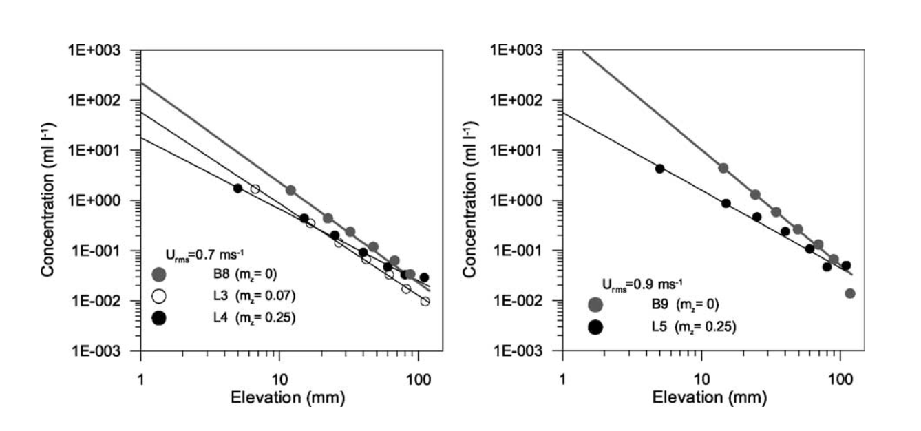 | 2002 | de Meijer et al. - 2002 - Gradation effects in sediment transport.pdf |
An inter-comparison of sediment classification methods based on multi-beam echo-sounder backscatter and sediment natural radioactivity data | This contribution presents an inter-comparison between two methods for sediment classification. The first source is a multi-beam echo-sounder (MBES). The second source is measurements taken with a gamma-ray scintillation detector, towed over the sediments and measuring sediment natural radioactivity. It is shown that although originating from completely different sources, the MBES and Medusa provide similar information, revealing the same sediment distribution. 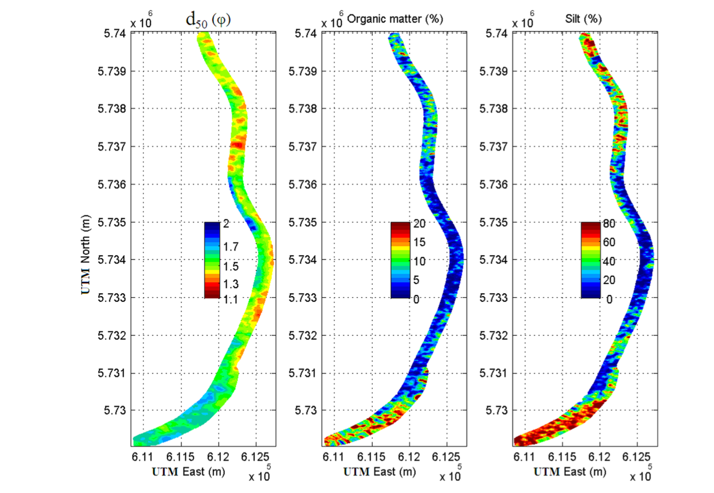 | 2013 |
{}