
Proximal sensing of clay
Dutch Wageningen University Uses Gamma-Ray Sensor to Reduce Risk of False Sampling
How do you increase the accuracy of taking samples in the field? Dutch Wageningen University & Research uses Medusa’s gamma-ray spectrometer to more accurately define its sample locations and thus reducing the risk of false sampling.
Wageningen Environmental Research (WENR) normally uses soil maps and data from BRO/BIS, but to sample heavy-loamy soils more accurately, the university tested Medusa’s sensing technology.
The tillage layer has been measured completely with Medusa’s gamma-ray spectrometer which led to the relocation of sampling points. “The use of the sensor has reduced the risk of ‘failures’in the field”, says a University representative. “A very good result and a useful application of sensor technology.”

A MS-4000 mounted on a quad bike for mapping a cropfield.
The following article is copied from the site of the university of Wageningen and alle rights belong to Wageningen Environmental research
Soil Hydro-Physics sampling site more accurate with sensor technology
The Dutch Soil Information System (SIS), which is part of the Key Registration Subsurface (BRO), includes a representative database of Soil Hydro-Physics (ShP) data of the Netherlands. The Soil, Water, Land use team of Wageningen Environmental Research (WENR) has been busy updating this data in the past year. This includes field sampling and analyzing new samples in the lab. The sampling locations are usually selected based on existing soil maps and profile data in BRO/SIS. To improve this methodology and to make it smarter, sensor technology has been used. An important goal for 2016 was sampling of heavy-loam soils, because their representation in the BRO is relatively low.
To be more sure about the occurrence of the heavy loam soils during sampling, two test location were selected for a trial. On these locations the most optimal sampling point is determined within the chosen plot by means of sensor technology. With the gammaspectrometer of Medusa Explorations the texture of the topsoil was measured in situ.

Grid measured with the gammaray spectrometer
A gammaspectrometer measures the natural radioactivity of the soil (0-30 cm), which is related to the texture of the soil. The measurement data are converted to clay content, and texture classes, using a general
correlation for the Netherlands.
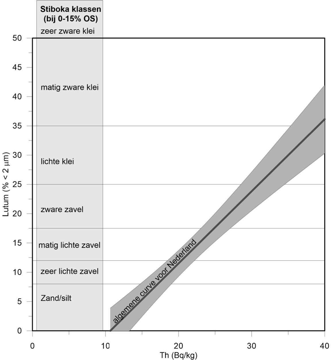
Correlation between clay content and the concentration of Th based on a large set of samples from dutch soils.
Based on this data in both cases the sample point, that was initially selected based on data in BIS and the soil map, was moved over short distances.
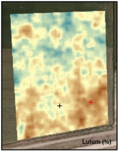
Soil map showing clay content of the field
The clay contents, as predicted by the gammaspectrometer, differs by 0.5% with the lab measured clay contents. The use of the sensor reduced the risk of "failures" in the field. A very good result and a useful application of sensor technology.
Literature
Van Der Klooster, E., F. M. van Egmond, M. P. W. Sonneveld, 2011. Mapping soil clay contents in Dutch marine districts using gamma‐ray spectrometry. European Journal of Soil Science, Vol.62(5), pp.743-753