
Monitoring Sludge Disposal
Dredging is essential to maintain navigation in ports and harbours. Much of the material that is removed during dredging is clean enough to be disposed of in open water depots at sea. According to the protocol defined in the London Convention (1972 and 1996), the impacts of these open water depots on the surrounding environment have to be monitored.
Thus far, monitoring of sediment mobility and sediment transport has mainly been carried out by point measurements. These measurements provide only limited information and sometimes require ambiguous extrapolations. With the development of systems that provide high-resolution, quantitative information of morphology and sediment composition we are able to measure and quantify the mobility of dumped dredge spoil.
Maintaining Rotterdam Harbour
Like many major ports of the world, Rotterdam harbour is almost continuously dredged to keep it accessible. Due to the improved quality of these sediments over recent years it has become possible to allocate silt spoil to open water depots.The closer these locations are to the dredging location, the lower the shipping costs. To minimise dispersion of the sludge, it is dumped in former gravel pits with a depth of about 10 metres, the socalled ‘Verdiepte Loswal’. Dumping began here early in 2000 and still continues. Monitoring of this dredge spoil is important to assess the effectiveness of the site and to investigate the environmental impact of dumping.
Sediment Transport
Successive measurements of water depth with, for example, a multibeam system, may be used to determine changes in morphology. The uncertainty of these determinations (typically 15cm in depth) prohibits the monitoring of dispersion of sediments from an underwater depot over large areas. The recent development of the ‘MEDUSA’ detector system is a result of a longstanding research programme aimed at developing geophysical methods providing quantitative information on sediment composition. With this system it has become possible to measure small changes in composition of the top layer of the sediment. MEDUSA is a detector system that utilises variations in the content of natural radionuclides between sediments. It is towed over the sediment behind a vessel (Figure 1) and determines the sediment composition (e.g. sludge concentration) and density each second.The system has been operated on various types of vessels in water depths ranging from 0.5m to 5km and can be used simultaneously with other monitoring devices such as echosounder or multibeam.The towing speed is up to 10km/h. Data obtained with the system provides maps with:
ı Texture
ı Silt concentration (kg/kg dry matter)
ı Sediment density (kg/l dry matter)
ı Sediment grain size (D50 in μm)
ı Pollution
ı Heavy metal concentration (kg/kg dry matter)
ı Concentration of PAH and PCB (kg/kg dry matter)
The combination of this data with detailed images of morphology obtained with a multibeam system gives highquality 3D visualisations of the underwater environment. Successive measurements of sediment composition show the behaviour of the sediment bed and reveal sediment transport patterns.
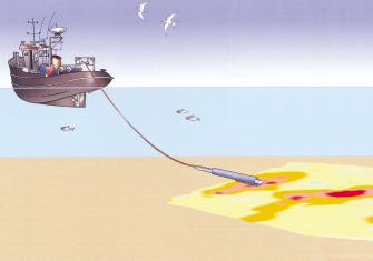
Figure 1: The MEDUSA system towed behind a vessel
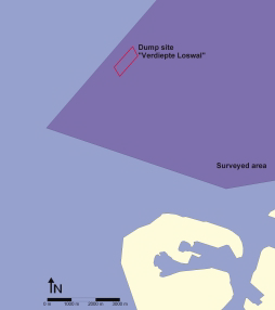
Figure 2: Location map of the survey area
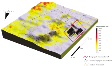
Figure 3: Sludge content (g/kg dry matter) and morphology in the study area
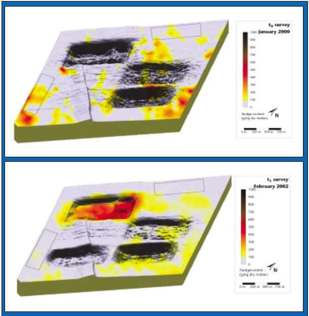
Figure 4: Distribution of sludge content (colour map) in the surveyed area around the dumping site (blue rectangle) before (t0 survey) and during (t1 survey) dumping. The 3D view shows bathymetry measured with multibeam
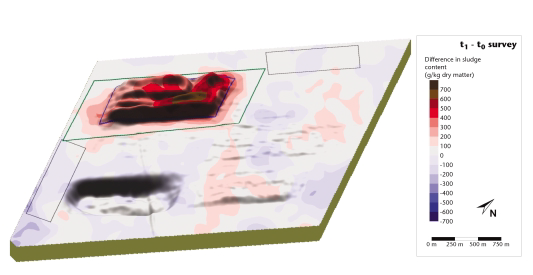
Figure 5: Difference in sludge fraction (colours) and difference in morphology (3D view) in the two measurements
Site Investigation
The National Institute for Coastal and Marine Management of the Dutch Ministry of Public Transport and Water Management (RIKZ/RWS) has initiated a monitoring project around the Verdiepte Loswal. Prior to dumping of dredge spoil the site is mapped with MEDUSA and with a multibeam system.This survey serves as a baseline measurement for future studies and has been used to investigate the texture and morphology of the studied area. Figure 2 shows the geographical situation of the harbour mouth, the dumpsite and the surveyed area.The survey was carried out in four days and comprises about 120,000 data points distributed over 90km2. Figure 3 shows sludge concentration and morphology in the survey area.The increased concentrations of sludge in the area east of the gravel pits (Verdiepte Loswal) originate from an abandoned dumpsite further north.
Dredge Disposal
Figure 4 shows sludge distribution in the area around the dumping site (blue rectangle) prior to dumping (t│ measurement) and after two years of use (t│ measurement). Between the surveys, 4.3 billion kilos (dry weight) sludge was dumped in the first pit, 500m wide and 1,250m long. At t│ the dumping site does not contain any sludge. The concentrates of sludge in the other parts of the area originate from a former dumpsite. At t│ dumping of harbour sludge may be clearly recognised by increased sludge concentration in the former gravel pit. Dispersal from the gravel pit is little; sludge extends only 250m around the sides of the pit.
Transporting Sludge
Transport of the sludge from the dumping site is quantified with a difference map (Figure 5), which in the 3D view shows the increase in volume and with colours the increase in sludge content of the sediment. These results show that the increase in sludge concentration on the dumping site coincides with the increase in bed height. Around the dumping site clays are dispersed to a maximum of 250 metres (denoted by the green rectangle). The variations of ~300g/kg in the other part of the area are the result of natural variations resulting from continuous transport of fine sediments at sea. With the information gathered during the two measurement campaigns, a mass balance is constructed that has been used to validate the results of model calculations. This quantitative information on the transport of sediment can help to refine models for an improved assessment of the effectiveness of a spoil depot.
Acknowledgements
The case-study presented in this paper was carried out for the National Institute for Coastal and Marine Management of the Ministry of Public Transport and Water Management (RIKZ/RWS) for the project ‘Monitoring alternatieve Loswallen’.
Biographies
Ronald Koomans is a geophysicist specialised in sediment characterisation in the marine and fluviatile environment. His PhD study concerned the study of graded sediment transport in the coastal zone. He is co-founder and director of Medusa Explorations BV a geophysical consultancy company that uses the MEDUSA system for in situ mapping sediment composition and sediment pollution in the field. Sandeh Stutterheim is an environmental chemist, working at the National Institute for Coastal and Marine Management,The Netherlands, as both researcher and research manager.
2004_04_Hydro Intern, Koomans & Stutterheim_Monitoring Sludge Disposal.pdf