
Soil moisture
Overview
Gamma-ray spectrometry is a non-invasive technique that measures natural background radiation emitted by isotopes such as potassium (40K), uranium (238U), and thorium (232Th) that are present in the soil. Large-scale variations in the gamma signal are typically due to differences in soil texture and mineral composition—for example, clay-rich soils emit more radiation than sandy soils. However, soil moisture introduces more subtle, short-term fluctuations. Water in the soil attenuates gamma radiation, meaning higher moisture content results in a lower detected gamma signal. This sensitivity to moisture allows gamma-ray sensors to indirectly quantify soil water content, making the method highly suitable for spatial and temporal moisture assessments.
Gamma radiation in the energy range of 0.3–3 MeV, which is relevant to the mentioned natural radionuclides, is significantly attenuated by water, more than most common soil materials. When soil moisture increases, pore spaces in soil are filled with water, leading to a decrease in the measured concentration of radionuclides . Essentially, the presence of water weakens the signal read by the sensor.
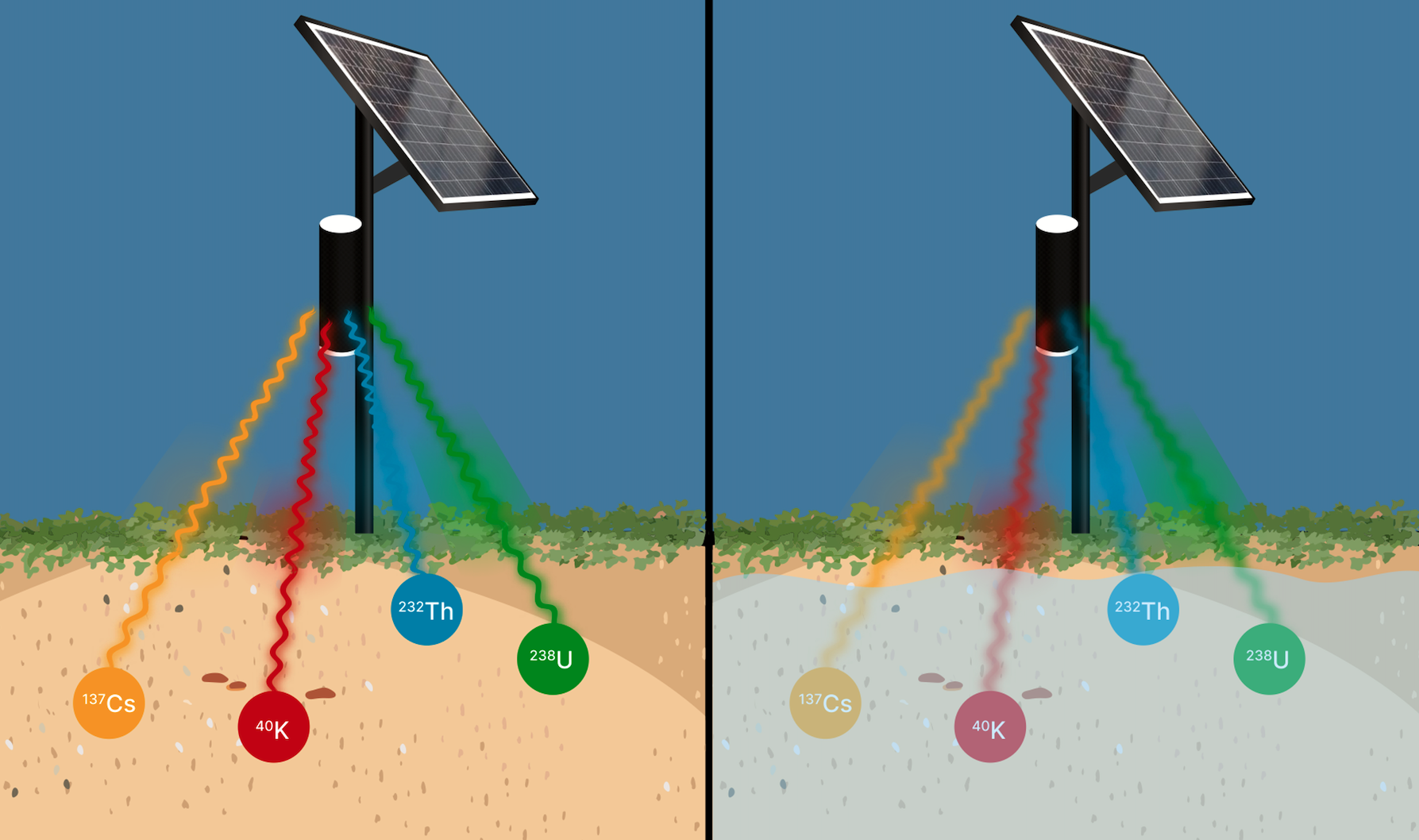
A simple illustration of the soil moisture measurement through gamma-ray spectrometry. The signal read on the left (dry soil) is higher than the signal read on the right (wet soil). The amount of this change represents the change in the moisture content of soil.
Stationary Measurements
Stationary systems like the Medusa gSMS-100 are used for continuous, high-resolution monitoring at a fixed location. These sensors measure gamma radiation over time, allowing detection of changes in soil moisture linked to rainfall, evaporation, or irrigation. Because the sensor remains at a fixed point, it offers highly accurate time series data that reflect temporal moisture dynamics. The gSMS is particularly valuable in long-term monitoring applications, such as tracking peatland degradation or assessing irrigation practices, where consistent measurements are critical.
The figure on the right shows the setup of a gSMS sensor that makes stationary soil moisture measurement. The sensor should have a robust and waterproof structure and use solar energy for its operation, allowing it to take long-range measurements in all weather conditions. The size of the area that gSMS measures is also fairly unique when it is compared to other methods. Satellite measurements cover very large areas compared to the size of an average field. With point-scale sensors, in the other end of the spectrum, it is difficult to obtain a precise understanding of representative soil moisture temporal dynamics of a specific land cover.
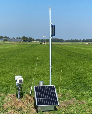
A typical gSMS setup.
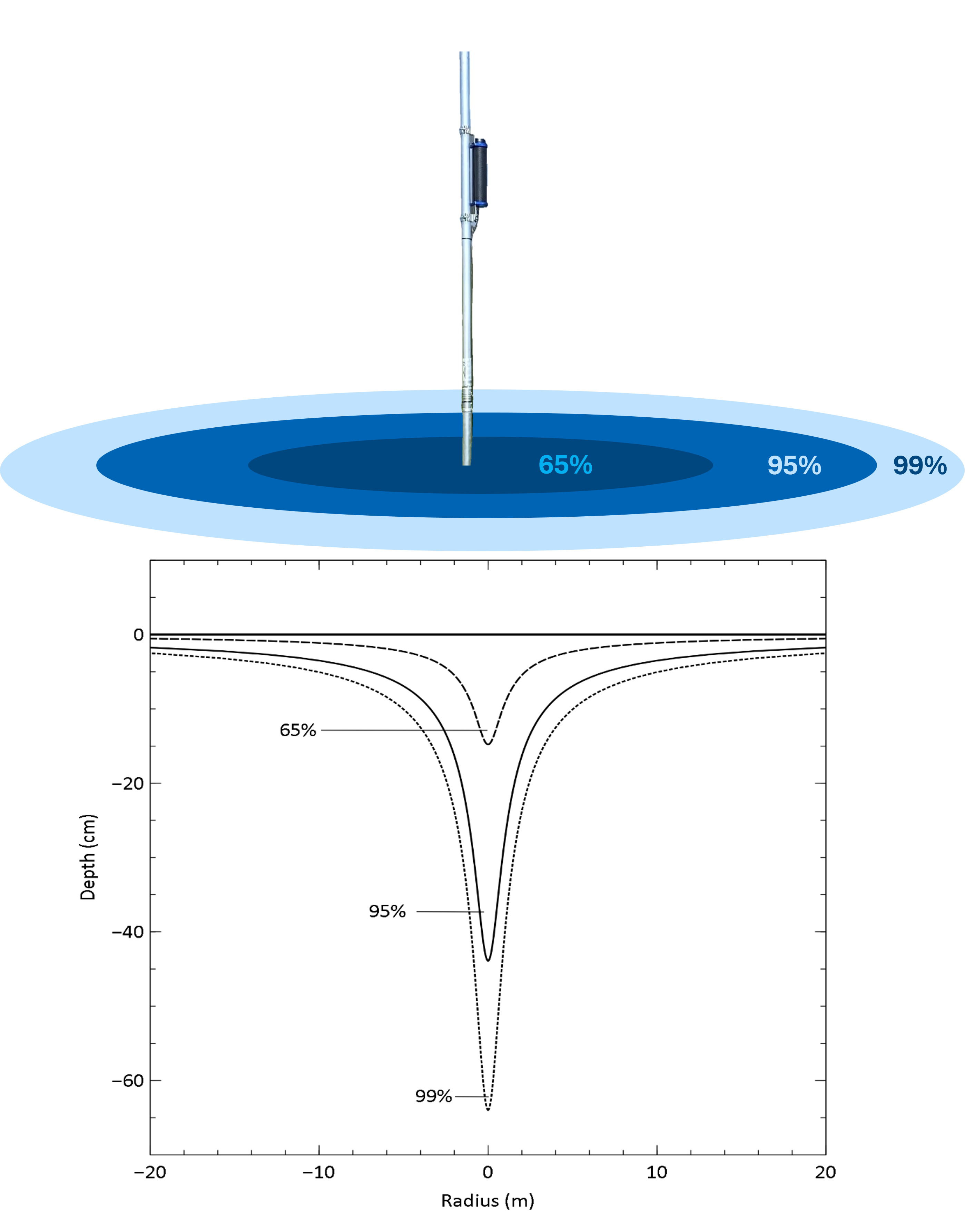
An illustration of the footprint of a gSMS sensor
The coverage area of a stationary GRS is determined by the height at which it is hung. Depending on the radionuclide type, the measurement area increases with the height at which the sensor is mounted. This is called the footprint of a gamma-ray sensor. The figure on the left illustrates roughly what a footprint looks like. As a rule of thumb, 95% of the signal of a gamma-ray sensor hung at 2 m measures comes from a radius of 30 m.
Spatial Mapping
Drone-borne gamma-ray spectrometry extends this technique to spatial surveys, capturing moisture variability across entire fields. Repeated (drone-borne) measurements over the same area make it possible to monitor both spatial and temporal changes in soil moisture. This approach combines the benefits of large-area coverage with non-invasive, repeatable measurements, providing an efficient tool for agricultural management and environmental monitoring.
Spatial mapping at different heights gives the chance to customize the coverage area.
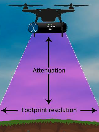
Footprint of a detector mounted on a drone.
Conclusions
Gamma-ray spectrometry offers a powerful, non-invasive method for monitoring soil moisture by detecting variations in natural background radiation. Whether deployed in stationary systems like the gSMS for continuous time-series data or used in drone-based surveys for spatial mapping, this technique provides accurate, scalable insights into moisture dynamics. Its flexibility and precision make it a valuable tool for both agricultural management and environmental research.
References
Andreasen, M., Van der Veeke, S., Limburg, H., Koomans, R., & Looms, M. C. (2025). Soil moisture time series using gamma‐ray spectrometry detection representing a scale of tens‐of‐meters. Water Resources Research, 61, e2024WR039534.
Baldoncini, M., Albéri, M., Bottardi, C., Chiarelli, E., Raptis, K. G. C., Strati, V., & Mantovani, F. (2019). Biomass water content effect on soil moisture assessment via proximal gamma-ray spectroscopy. Geoderma, 335(August 2018), 69–77. https://doi.org/10.1016/j.geoderma.2018.08.012
Hubbell and Seltzer, 2004, X-Ray Mass Attenuation Coefficients | NIST
van der Veeke, S. (2023). UAV-borne radioelement mapping: towards a guideline and verification methods for geophysical field measurements. [Thesis fully internal (DIV), University of Groningen]. University of Groningen. https://doi.org/10.33612/diss.261264637