
Drone-borne mapping
Title and download | Topic | Year |
|---|---|---|
Peat is notoriously hard to map. Coring is slow, access is difficult, and spatial coverage is therefore limited. A MS-350 gamma-ray sensor mounted on a drone is used to map peat thickness. The result was a detailed peat thickness map covering 118 hectares of a prospective wind farm site in Ireland. | 2026 | |
This article compares the accuracy of UAV-based measurements with backpack-based systems, particularly in mapping U-238 specific activities. The study finds that UAV-based systems can accurately measure radiation levels with sufficient spatial resolution, despite their lower spatial support compared to ground-based methods, making them suitable for large-scale uranium waste mapping. | 2024 | |
Guidelines for UAV-borne radioelement mapping (IAEA) 20230428 - Guidelines for UAV-borne radioelement mappinng (IAEA).pdf | A practical guide describing how to set-up a gamma-ray survey with a drone. About choice of sensor, flight lines, calibration, data analysis and reporting. These guidelines are summary from the PhD thesis of Steven van der Veeke, and are a deliverable from the IAEA CRP D12014. | 2023 |
UAV-borne radioelement mapping: towards a guideline and verification methods for geophysical field measurements | 2023 | |
Soil mapping with drones: the use of gamma-ray spectrometers in airborne surveys. | Soil Mapping with Drones 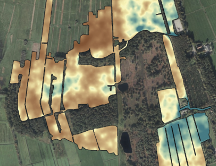 | 2022 |
Optimizing gamma-ray spectrometers for UAV-borne surveys with geophysical applications |  | 2021 |
Footprint and height corrections for UAV-borne gamma-ray spectrometry studies |  | 2021 |
Drone-borne gamma-ray spectrometry – a dream come true! | Drone-borne gamma-ray spectrometry – a dream come true! | 2020 |
Towards drone-borne gammaray mapping of soils Towards drone-borne gammaray mapping of soils_First Break.pdf | Towards drone-borne gammaray mapping of soils | 2019 |
{}