
Silt in sediments
Various research projects have shown how silt, sand and heavy minerals contain different concentrations and ratios of radionuclides (de Meijer, 1998). This method is also commonly used to measure median grain size in the field (Nederbracht & Koomans, 2005)and to map the concentration of silts in sediments (Venema & de Meijer, 2001; Wijngaarden, Venema, Meijer, & Zwolsman, 2002; Wijngaarden, Venema, & Meijer, 2002). The specific concentrations of these radionuclides for each sediment fraction (also called fingerprint) allows the measurements of the radionuclides in the sediment to be translated into maps of sediment composition.
The advantage of the proposed system over traditional sediment sampling is that the detailed maps of sediment composition determine the spatial variation at a small scale. Moreover, it is a cost-effective method for monitoring purposes.
Sludge mapping at sea
In a project for Rotterdam harbour, the transport of fine material, relocated to in several gravel pits, was monitored with the Medusa system and with a multibeam. Therefore, two surveys have been conducted: one survey prior to disposal and one survey after two years of disposal. An area of 10x9 km2 was monitored. The entire survey was carried out in four days and comprises about 120 .000 data points.
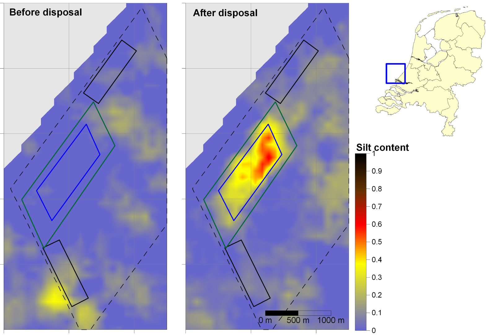
Comparison of silt fraction (ranging from 0 to 1) of total sediment of the seafloor, before and after disposal
The figure above shows the distribution of fine sediments in the area around the former gravel pits (blue rectangle). At t0, the disposal site does not contain any sludge. The concentrates of sludge in the other parts of the area originate from a former disposal site (Venema & de Meijer, 2001). At t1, the disposal of the harbour silts can clearly be noticed by the increased silt concentration in the former gravel pit. The dispersal from the gravel pit is small; the sludge extends only 250 m around the sides of the pit.
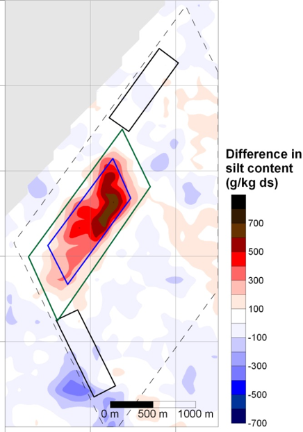
Map of the difference in silt content of the sediment before and after disposal
The transport of the sludge from the dumping site is quantified with a map showing the difference between the two measurements. With this information, a mass balance is constructed that has been used to validate the results of model calculations. The quantitative information on the transport of sediment can help to refine models for an improved assessment of the effectiveness of a spoil depot. This application is described in our application section: Ecological assessment and sediment mapping.
Summary
Radiometric mapping offers efficient and cost-effective method for assessing sediments compositions, particularly silt content, in marine environments. By analysing radionuclide fingerprints, detailed maps of sediment distribution can be produced, improving understanding of spatial variability. A case study in Rotterdam harbour demonstrated the method’s effectiveness in tracking silt dispersion sites. The resulting data not only confirmed limited sludge spread but also supported sediment transport models through mass balance calculations, enhancing the evaluation of dredging and sediment management strategies.
References
Wijngaarden, M. Van, Venema, L.B., Meijer, R.J. De, Zwolsman, J.J.G., 2002. Radiometric sand – mud characterisation in the Rhine – Meuse estuary Part A. Fingerprinting. Geomorphology 43, 87–101.
Hebinck, K., Middelkoop, H., Diepen, N. Van, Graaf, E.R. Van Der, Meijer, R.J. De, 2007. Radiometric fingerprinting of fluvial sediments in the Rhine-Meuse delta, the Netherlands – a feasibility test. Netherlands J. Geosci. 3, 229–240.
van der Graaf, E.R., Koomans, R.L., Limburg, J., de Vries, K., 2007. In situ radiometric mapping as a proxy of sediment contamination: assessment of the underlying geochemical and -physical principles. Appl. Radiat. Isot. 65, 619–33. doi:10.1016/j.apradiso.2006.11.004
Van Der Klooster, E., Van Egmond, F.M., Sonneveld, M.P.W., 2011. Mapping soil clay contents in Dutch marine districts using gamma-ray spectrometry. Eur. J. Soil Sci. 62, 743–753. doi:10.1111/j.1365-2389.2011.01381.x
Koomans, R.L., Vries, S. De, Limburg, J., 2016. An Underwater Gamma Spectrometer as Tool for Ecological Assessment, in: Near Surface Geoscience. EAGE, Barcelona, Spain.